Arunachal Pradesh,Assam,Manipur,Maghalaya,Mizoram, Nagaland & Tripura and the Himalayan state of Sikkim* Population-38857769* Population Density-262230 km sqm*
About
our Northeast Region........
Northeast India is the eastern-most region of India connected to East India via a narrow corridor squeezed between Nepal and Bangladesh. It comprises the contiguous 7 states like , Arunachal Pradesh,Assam,Manipur,Maghalaya,Mizoram, Nagaland & Tripura and the Himalayan state of Sikkim. These states are grouped under the MDONER ministry of the Govt. of India. Except for the Goalpara Region of Assam, the rest were late entrants to political India—the Brahmaputra Valley of Assam became a part of British India 1824, and the hilly regions even later. Sikkim was recognised as a part of North-East states in the 1990s.
The Siliguri Corridor in W.B.with an average width of 21 to 40 kilometres (13 to 25 mi),connects the North Eastern region with the mainland Indian sub-continent. The region shares more than 4,500 kilometres (2,800 mi) of international border (about 90 per cent of its entire border area) with China in the north, Myanmar in the east, Bangladesh in the southwest, and Bhutan to the northwest.
The states are officially recognised under the Northeast Council (NEC) constituted in 1971 as the acting agency for the development of the eight states. The North Eastern Development Finance Corporation Ltd (NEDFi)was incorporated on 9 August 1995 and the Ministry of Development of North Eastern Region(DONER) was set up in September 2001.


MEGHALAYA
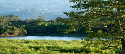
Emergence of Meghalaya as an Autonomous State on 2nd April 1970 and as a full-fledged State on 21st January 1972 marked the beginning of a new era of the geo-political history of North Eastern India. It also marked the triumph of peaceful democratic negotiations, mutual understanding and victory over violence and intrigue.The State of Meghalaya is situated on the north east of India. It extends for about 300 kilometres in length and about 100 kilometres in breadth. It is bounded on the north by Goalpara, Kamrup and Nowgong districts, on the east by Karbi Anglong and North Cachar Hills districts, all of Assam, and on the south and west by Bangladesh.Shillong, the capital of Meghalaya is located at an altitude of 1496 metres above sea level. Shillong, which was made Assam's capital in 1874, remained so till January 1972, following the formation of Meghalaya. The capital city derives its name from the manifestation of the creator called Shyllong.Meghalaya is subject to vagaries of the monsoon. The climate varies with altitude. The climate of Khasi and Jaintia Hills is uniquely pleasant and bracing. It is neither too warm in summer nor too cold in winter, but over the plains of Garo Hills, the climate is warm and humid, except in winter. The Meghalayan sky seldom remains free of clouds. The average annual rainfall is about 2600 mm over western Meghalaya, between 2500 to 3000 mm over northern Meghalaya and about 4000 mm over south-eastern Meghalaya. There is a great variation of rainfall over central and southern Meghalaya. At Sohra (Cherrapunjee), the average annual rainfall is as high as 12000 millimetres, but Shillong located at a distance of about fifty kilometres from Sohra receives an average of 2200 mm of rainfall annually.
The Governor: All
Executive Authority of the State formally vests in the Governor. In
actual practice, however, he acts as the Constitutional Head of the
State Government. Every act or decision of the Governor is
impressed to be taken in his name. Every such act or decision is
based on a decision taken by the Council of Ministers or under the
authority of a Minister except in so far as the Governor is by or
under the Constitution required to exercise his function on any of
them in his decision
Council of
Ministers: The executive power of the State
Government is exercised by the Council of Ministers with the Chief
Minister as its head. The Chief Minister is appointed by the
Governor.
ASSAM-A STATE OF BEAUTY
Assam (Asom, Axom) is a
beautiful and diverse state with an incredible range of cultures
and landscapes located in the northeast of India. It shares it’s
borders in the North and East with the Kingdom of Bhutan and
Arunachal Pradesh.
|
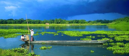
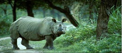
Kaziranga
National Park is spread over 858 sq.kms and is
located in the floodplains on both sides of the Brahmaputra.
Patches of mixed deciduous forests are interspersed with vast
stretches of savannah grasslands, wetlands and chars of river
islands formed by the shifting course of the Brahmaputra
*Manas National Park
Located in the Himalayan
foothill bhabararea in the western Assam, Manas was originally a
game reserve since 1928 and became a Tiger Reserve in 1974, a World
Heritage Site in 1985, a Biosphere Reserve in 1989. Then declared
as a National Park in 1990.*Nameri National
Park covers an area of 200 sq. kms. and is located in
the Sonitpur district, bordering Arunachal Pradesh. It is also the
core area of Nameri Tiger Reserve (344 Sq. km). It's beautiful
deciduous forests and the adjacent river jia Bhoreli, fringe the
border of Assam and Arunachal Pradesh. This is therefore a popular
stop en route to Bhalukpung in Arunachal, where anglers congregate
to fish for the famous
golden MahseerDibru-Saikhowa National
Park is a National Park as well as a
Biosphere Reserve having an area of 340 sq. kms. in Tinsukia
district. An unique habitat endemic to Dibru-Saikhowa only, a
habitat which has undergone radical transformation after the great
earthquake of 1950. It is famous for it's feral horses and Gangetic
dolphins. The migratory birds are also a major
attraction.

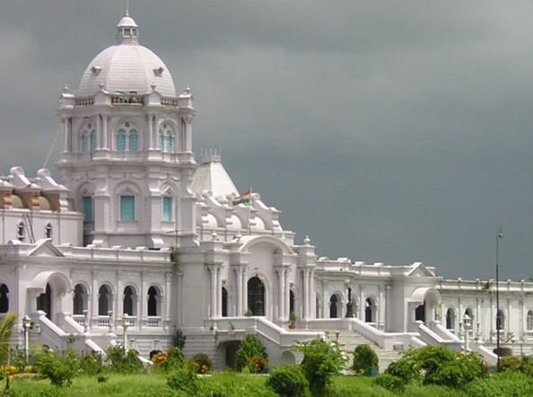
TRIPURA
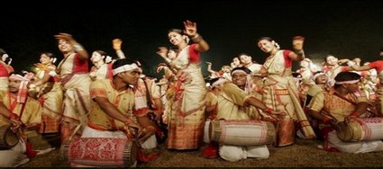
Quietly nestled in the lush greenery of hills, verdant valleys and transparent waterscape, Tripura, a land of plentiful myths and legends, beckon tourists from across the globe. This state, home to nineteen indigenous tribal groups, Bengali speaking non-tribals and a diversity of culture, resembles a tiny dot on the peninsular India's map dangling between Northeast India and Bangladesh. But the wealth of Tripura's traditional art, culture, history and archaeology, flora and fauna, biodiversity and flushing meadows always cast a magnetic spell on casual visitors and tourists. The state's rich handicrafts, traditional music, diversity of cultural streams and faiths, co-existing down the annals of history in pristine peace constitute its irresistible charm as a tourist destination. Any visitor or tourist in Tripura can trace the state's glorious history in its archaeological remains, cultural heritage, exquisite sculpture and architecture spread across its landscape and return, richer by a finer aesthetic sense and sensibility.
Tripura: Origin and History
Origin the origin of the name of Tripura is still a matter of controversy among historians and researchers. According to the 'Rajmala", Tripura’s celebrated court chronicle, an ancient king named 'tripur' ruled over the territorial domain known asTripura' and the name of the kingdom was derived from his name.Many researchers explain the name 'Tripura' from its etymological origin: the word 'Tripura' is a compound of two separate words, 'tui' (water) + 'pra' (near) which in totality means 'near water'. The geographical location of the state with it's close proximity to the vast water resources of eastern Bengal coupled with the generic identity of the state's original inhabitants as 'Tipra' or 'Twipra' apparently justify this explanation of the State's name.There are a number of socio-religious fairs and festivals celebrated in the State throughout the year. Practically each tribe in the state has its own dances and festivals, which are celebrated with great devotion and enthusiasm.Tripura is a erstwhile princely state. Pollution free, eco friendly environment and pleasant weather of this panoramic state is inhabited largely by 19 Tribes, Bengali and Manipuri etc. communities. Following are the places of a tourist interest in the state of Tripura.


MANIPUR
Manipur came under British rule as a princely state (kangleipak) in 1891. During world war 2 Manipur was the scene of many fierce battles between the Japanese and the Allied Forces . The Japanese were beaten back before they could enter Imphal which was one of the turning points of the war. After the war, the Manipur Constitution Act of 1947 established a democratic form of government, with the Maharaja as the Executive Head and an elected legislature. When India achieved independence in 1947, Manipur acceded to the new Union. In 1949, Maharaja Budhachandra was summoned to,Shillong capital of the then-Indian province of Assam. The legislative assembly was dissolved on the controversial annexation of the state with the republic of India (In gunpoint under Merger Agreement) in October 1949.Manipur was a union territory from 1962 and later became a full-fledged state in 1972.M.K. Priyobarta became the first state Chief Minister (1972–74).A separatist movement has been active in Manipur since 1964 with the establishment of the United National Liberation Front several groups have used violence to achieve their goal of a sovereign Manipur from Indian colonial rule.Foreign travelers to Manipur must gain special permission to enter, as it is considered a "sensitive area" due to its political troubles and geographical location.
-
Manipur
-
Manipur maṇipur is a state in northeastern India, with the city of Imphal as its capital. Its people include the Meitei, Pangal, Naga, and Kuki, who speak different languages of branches of the Tibeto-Burman family.
Twitter Feed
- No results


Join our
newsletter
Sign up for our newsletter
so we get send you the latest events and promotions we have going
directly to your e-mail. If you are interested we can also let you
know about other sporting events that are happening around the
city. So sign up today!
For our SMS alert plz
contact our sms divission
09774294534